S269 Diary Block 2
I suppose, on some sort of schedule, I have read this block and made a first draft of the TMA. It was VERY difficult (the reading and the TMA) - by far the most difficult I've had to do in my OU career so far. It's nice to now be able to pick up Hilma's loaned copy of Book 3 and actually understand something!
3rd February 2004
I started on Block 2, The Dynamic Earth, yesterday - and am struggling terribly with it. (I think I would've given up on it completely, had it not been for the fact that registration on other courses is now closed!)
OK, Questions at the end of Chapter 1 (and the model answers; I do do these - but my answers aren't as good!)
Q. Mars is an arid planet where stgrong winds sometimes whip up dust clouds, but clouds of condensed water (as ice because of the low pressure) ar emuch less common than on Earth. Venus is totally covered in a thick layer of cloud (which, incidentally, seems to be ~75% sulfuric acid and ~25% water). How would you expect the planetary albedos of Mars and Venus to compare with that of the Earth?
A. The martian suface must have an albedo appropriate to bare rock/soil (10-20% according to Table 1.1), and dust must have a relatively low albedo (ie closer to that of rock or soil than of clouds or ice). The albedo of Mars as a whole must therefore be significantly lower than the 30% value for Earth. Mars' value is in fact 14%. By contrast, thick cloud is very reflective (albedo up to 80%) so Venus must have an albedo significantly greater than 30%; its value is in fact 77%. This high albedo (coupled with Venus' relatively close proximity to the Earth) is why Venus shines so brightly in the night sky.
Q. The Tropics of Cancer and Capricorn are not shown on Figure 1.7. Why is this?

A. The Tropics are not shown on Figure 1.7 because they are the latitudes at which the noonday Sun is overhead at the summer solstices. They are therefore a consequence of the tilt of the Earth's axis with respect to the plane of the Earth's orbit (which is why the latitude of the Tropics 23.4 deg, is the same as the angle of tild of the axis). If the axis were not tilted - the hypothetical situation illustrated in Figure 1.7 - the whole idea of Tropics would be meaningless.
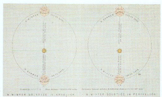
Q. (a) Croll's Frontispiece to Climate and Time (fig 1.12) shows a way in which the interaction of two of the three astonomical cycles might possibly lead to glaciations in one or mother hemisphere.
(i) Which two cycles are involved?
(ii) Can you suggest what Croll's argument might have been?
A. (a) (i) The diagram shows the Earth in perihelion and aphelion in two different circumstances: one with the axis tilted so the North Pole is pointing away from the Sun (the northern winter solstice) at aphelion and towards it at perihelion; and the other with the reverse. The cyclical variations involved are therefore those in orbital shape (the 110 000-year eccentricity cycle) and the direction of tilt of the Earth's axis (the 22 000-year precession cycle).
(ii) The diagram illustrates Croll's idea that glacial conditions become established in a particular hemisphere when the coldest season (ie when the hemisphere is 'away from the Sun') coincides with the time in the orbit when the Earth is farthest from the Sun. This is despite the fact that the hemisphere in question will be experiencing summer when closest to the Sun. The implication of this is that Croll believed that whether ice-sheets persist depends on how low temperatures are in winter, not how high they are in summer.
Q. (b) One of the two diagrams in figure 1.12 is intended to represent the present-day situation. Which is it? And how far apart in time are the two orbital configurations.
A. (b) As shown in Figure 1.8a, at the present time, perihelion occurs during the northern winter, close to the southern summer solstice (ie when the North Pole is pointing away from the Sun). This is the situation shown in the second diagram. The two diagrams are half a precession cycle, ie.e 11 00 years, apart.
Q. (c) To what extent does the situation illustrated for the present day actually correspond to that seen on the Earth now?
A. (c) According to the second illustration, conditions in the Northern Hemisphere (where winter coincides with perihelion) should be 'interglacial', while in the Southern Hemisphere (where winter coincides with aphelion) conditions would be 'glacial'. Present-day conditions in the Arctic might well be viewed as 'interglacial' in comparison with the more extremem 'glacial' conditions in the Antarctic (the Antarctic ice-cap is considerably more extensive than the Arctic ice-cap, and the Antarctic is colder than the Arctic). In fact, modern climatologists regard the Earth as currently in an interglacial period within an Ice Age.
(clear as mud)
Back to S269